Call Us Now
 Email Us Now
Directions
Directions to our main offices and Map (below):
From the South, Southeast and West:
From the:
- Ben Franklin Bridge, Take 1-676 (RT. 42) to I-295 North (see 295 North below)
- Walt Whitman Bridge, Take I-76 (RT. 42) to I-295 North
- Commodore Barry Bridge, Take RT. 322 to I-295 North
- Delaware Memorial Bridge, Take I-295 North
- Turnpike EXIT 3, RT. 168 (Black Horse Pike) to I-295 North
- Route 55, Take RT. 42 North (N-S FREEWAY) to I-295 North
- Atlantic City Expressway, Take (RT.42) to I-295 North
Take I-295 North:
- Take Exit 29B (Route 30 West)
- Merge onto Rt. 30 (White Horse Pike).
- Continue to BEAR RIGHT at the first traffic light onto Route 573 North (Highland Ave.), (DO NOT ENTER THE JUG HANDLE INTERSECTION)
- Travel about 1.3 miles to the first traffic light and turn right onto Kings Highway.
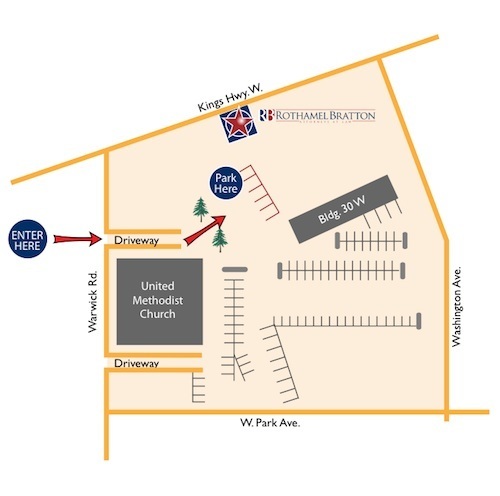
- Go to the first light and turn right onto Warwick Road. You will see Haddonfield United Methodist Church immediately on your left
- Make an IMMEDIATE left into the driveway of the church parking lot, past the play ground (on left)
- Make an IMMEDIATE left turn between two tall trees and drive toward the back of the buildings facing Kings Highway. You will see a low red brick wall surrounding the back of our building where parking is available.
Reference our user-friendly map below.
You can download the map in Adobe Acrobat PDF file format by clicking the link here –> RB New Address Map
From the North, Northwest and East:
From the:
- Betsy Ross Bridge, Take RT. 90 to Rt. 73 to I-295 South (See 295 South Below)
- Tacony Palmyra Bridge, Take Rt. 73 South to I-295 South
- Bristol Burlington Bridge, Take Rt. 541 East to I-295 South
- Turnpike EXIT 4, TO RT. 73 North to I-295 South
- Take Route 70 EAST to I-295 South
Take 1-295 South:
- Take Exit 30 (Warwick Road)
- Follow exit ramp to stop sign.
- At the top of the ramp turn left onto Warwick Road.
- Travel about 1.4 miles and you will see Haddonfield United Methodist Church on the right BEFORE the first traffic light.
- Turn RIGHT into the driveway to the church parking lot, past the play ground (on left)
- Make an IMMEDIATE left turn between two tall trees and drive toward the back of the buildings facing Kings Highway. You will see a low red brick wall surrounding the back of our building where parking is available.
Reference our user-friendly map below.
You can download the map in Adobe Acrobat PDF file format by clicking the link here –>
RB New Address Map